
for Saturday, 18 January 2014 [10:45 AM PhT]
WEATHER.COM.PH TROPICAL CYCLONE UPDATES
TROPICAL DEPRESSION 91W (AGATON) UPDATE NUMBER 001
Issued at: 8:00 AM PhT (00:00 GMT) Saturday 18 January 2014
Next Update: 12:00 PM PhT (04:00 GMT) Saturday 18 January 2014
The broad Tropical Disturbance (LPA) which has been lingering near the waters of Eastern Visayas and Northeastern Mindanao has strengthened into a Tropical Depression 91W [AGATON]...threatens Surigao Provinces including Dinagat and Siargao Islands. Heavy rains affecting Samar and Leyte Provinces.
This depression will continue to enhance the cool surge of the Northeast Monsoon (Hanging Amihan) - bringing mostly cloudy conditions w/ passing slight to moderate rains and gusty winds across Luzon including Bicol Region and some parts of the Visayas today through Monday.
Residents and visitors along Northeastern and Northern Mindanao, and Eastern Visayas should closely monitor the development of 91W.
Do not use this for life or death decisions. This update is intended for additional information purposes only. Kindly refer to your national weather agency for official warnings, advisories or bulletins.
CURRENT CYCLONE INFORMATION
As of 6:00 AM PhT today...2200 GMT
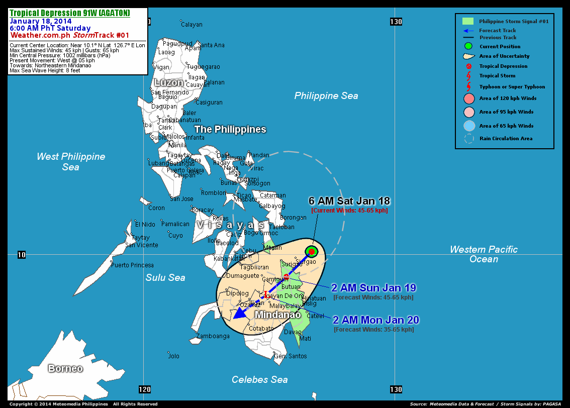
Location: Over the South Philippine Sea (near 10.1N 126.7E)
About: 70 km east-northeast of Siargao Island...or 150 km southeast of Guiuan, Eastern Samar
Maximum Sustained Winds (1-min avg): 45 km/hr near the center...Gustiness: 65 km/hr
24 hr. Rain Accumulation (near the center): Extreme [200 mm]
Present Movement: West-northwest at 5 kph
Towards: Northern Caraga and Northern Mindanao Area
2-DAY FORECAST OUTLOOK*
TD 91W (Agaton) is expected to move southwestward during the next 24 to 48 hours. On the forecast track, the core of TD 91W will make landfall along the Surigao Del Norte-Del Sur Border later tonight...and traverse provinces of Agusan Del Norte and the eastern part of Misamis Oriental through Sunday evening. By Monday early morning, TD 91W will be over the Northern Bukidnon.
TD 91W (Agaton) is expected to maintain its strength within the next 24 hours and will weaken into an area of low pressure through 48 hours due to its passage across the landmass of Northern Caraga and Northern Mindanao. Advance Intensity Forecast (AIF) shows its 1-minute maximum sustained winds decreasing to 35 km/hr on Monday early morning.
The following is the summary of the 2-day forecast outlook on this system:
 SUNDAY EARLY MORNING: Makes landfall over Northern Caraga...about 30 km NNE of Butuan City [2AM JAN 19: 9.1N 125.7E @ 45kph].
MONDAY EARLY MORNING: Weakens into an area of low pressure...just off the northern part of Bukidnon [2AM JAN 20: 8.4N 124.9E @ 35kph].
*Please be reminded that the Forecast Outlook changes every 6 hours, and the Day 2 and 3 Forecast Track has an average error of 100 and 250 km respectively...while the wind speed forecast error, averages 35 kph per day. Therefore, a turn to the left or right of its future track and changes in its wind speed must be anticipated from time to time.
POTENTIAL HAZARDS AFFECTING LAND
Below are the regions or places with possible or ongoing effects caused by the current tropical cyclone:
NORTHERN CARAGA - Moderate to heavy rains of 30 to 100 mm will be experienced along these areas...becoming heavy to extreme rains of more than 100 mm along the provinces of Surigao Del Norte, Dinagat and Siargao Islands. EASTERN VISAYAS - Heavy rains of 50 to 100 mm will be experienced along these areas...becoming heavy to extreme rains of more than 100 mm along the southern portions of the provinces of Eastern Samar and Samar, Southern Leyte and the eastern portions of Leyte. NORTHERN PART OF NORTHERN MINDANAO - Moderate to heavy rains of 30-50 mm will be experienced along these areas.
Important Note: Please keep in mind that the above forecast outlook and hazards summary changes every 6 to 12 hrs!
CURRENT TECHNICAL INFORMATION
Time/Date: 6:00 AM PhT Sat Jan 18, 2014
Class/Name: TD 91W (Agaton)
Location of Center: Near 10.1º N Lat 126.7º E Lon
Distance 1: 70 km ENE of Siargao Island
Distance 2: 135 km ENE of Surigao City
Distance 3: 150 km SE of Guiuan, E.Samar
Distance 4: 210 km ESE of Maasin City
Distance 5: 220 km SE of Tacloban City
MaxWinds (1-min avg): 45 kph near the center
Peak Wind Gusts: 65 kph
Present Movement: West @ 05 kph
Towards: Northern Caraga-Northern Mindanao Area
Minimum Central Pressure: 1002 millibars (hPa)
T2K/WP StormTracks (for Public): GIF
CURRENT TRACKING MAP:
 _____________________________________________________________________________
__________________________________________________________________________________________________
CURRENT NOAA/MTSAT-2 INFRARED (IR) SATELLITE IMAGE:

__________________________________________________________________________________________________
>> To know the meteorological terminologies and acronyms used on this update visit the ff:
http://typhoon2000.ph/tcterm.htm
http://www.nhc.noaa.gov/aboutgloss.shtml
http://www.nhc.noaa.gov/acronyms.shtml
__________________________________________________________________________________________
For the complete details on TD 91W (AGATON)...go visit our website @:
> http://www.typhoon2000.com
> http://www.maybagyo.com
<<<Typhoon2000.com Mobile >>>
Get the latest SMS Storm Alerts!
For more details: Text T2K TYPHOON to
2800 (Globe/TM) | Offline (Smart/TNT) | 2288 (Sun)
*Only P2.50 (Smart/Globe) / P2.00 (Sun) per msg received.
Click here on how to use this service (in PDF file)
Powered by: Synermaxx Corporation
Copyright © 2013 Typhoon2000.com All Rights Reserved
| Reply via web post | Reply to sender | Reply to group | Start a New Topic | Messages in this topic (1) |

No comments:
Post a Comment