
for Friday, 01 February 2014 [4:54 AM PhT]
WEATHER.COM.PH TROPICAL CYCLONE UPDATES
TROPICAL STORM KAJIKI (BASYANG) UPDATE NUMBER 005
Issued at: 1:00 AM PhT (17:00 GMT) Saturday 01 February 2014
Next Update: 6:00 AM PhT (22:00 GMT) Saturday 01 February 2014
Tropical Storm KAJIKI (BASYANG) has started crossing the Visayas after traversing Siargao, Dinagat and Surigao City. Its thick convective rainbands has been moving ahead of its center across Bohol, Cebu and Negros - bringing moderate to heavy to sometimes extreme downpours which could trigger flashfloods and landslides.
Kajiki (Basyang) will continue to enhance the cool surge of the Northeast Monsoon (Hanging Amihan) - bringing mostly cloudy conditions w/ passing drizzles, slight to sometimes moderate rains and gusty winds (not exceeding 50 kph across the eastern sections of Luzon including Bicol Region and some parts of Northern Visayas this weekend.
Residents and visitors along Northeastern Mindanao and the Visayas should closely monitor the development of TS Kajiki (Basyang).
Information based on data collected by WeatherPhilippines Foundation, Inc. shall not be taken as official data. Weather information broadcasted and distributed by PAGASA remains as official data. WeatherPhilippines shall not be responsible for the private use and reliance of its weather information.
CURRENT CYCLONE INFORMATION
As of 11:00 PM PhT today...1500 GMT...
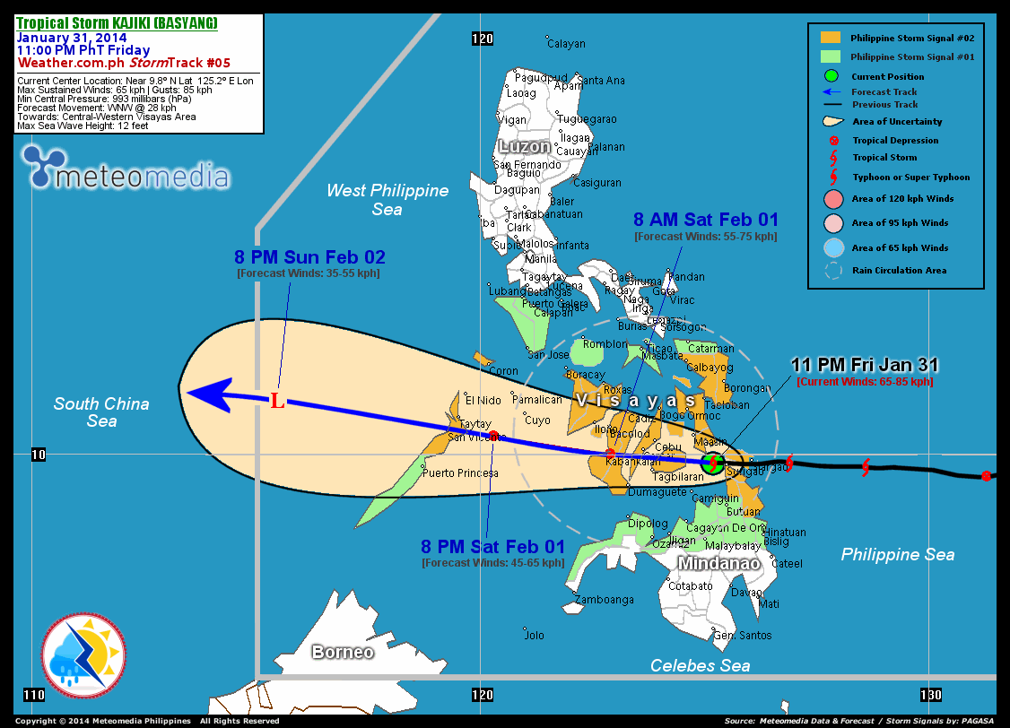
Location: Over Bohol Sea (near 9.8N 125.2E)
About: 100 km west of Siargao Island...or 155 km east-southeast of Cebu City
Maximum Sustained Winds (1-min avg): 65 kph near the center...Gustiness: 85 kph
24 hr. Rain Accumulation (near its center): 300 mm [Extreme]
Size (in diameter): 500 km (Small)
Past Movement: West at 31 kph
Forecast Movement: West to West-northwest at 28 kph
Towards: Bohol-Cebu-Negros Area
2-DAY FORECAST OUTLOOK*
Kajiki (Basyang) is expected to continue moving west to slightly west-northwestward within the next 24 to 48 hours. On the forecast track, the core of TS Kajiki (Basyang) will traverse Bohol, Cebu and Negros late tonight to early Saturday morning...and cross Sulu Sea before traversing Northern Palawan on Saturday evening. Kajiki will then be over the West Philippine and South China Seas on Sunday evening.
Kajiki (Basyang) is expected to weaken within the next 12 hours...becoming a Tropical Depression through the next 24 hours due to land interaction. Advance Intensity Forecast (AIF) shows its 1-minute maximum sustained winds decreasing to 55 kph on Saturday morning due to its frictional effects on the Visayan Terrain.
The following is the summary of the 2-day forecast outlook on this system:
 SATURDAY EVENING: Weakens to a TD as it moves across the Sulu Sea, approaching Northern Palawan...about 110 km ESE of San Vicente, Palawan [8PM FEB 01: 10.4N 120.3E @ 55kph]. SUNDAY EVENING: Dissipates into an area of low pressure while moving across the West Philippine Sea, out of the Philippine Area of Responsibility (PAR)...about 130 km ENE of Pagasa Island, Spratlys [8PM FEB 02: 11.2N 115.5E @ 35kph].
*Please be reminded that the Forecast Outlook changes every 6 hours, and the Day 2 and 3 Forecast Track has an average error of 100 and 250 km respectively...while the wind speed forecast error, averages 35 kph per day. Therefore, a turn to the left or right of its future track and changes in its wind speed must be anticipated from time to time.
CYCLONE HAZARDS AFFECTING LAND
Below are the regions or places with possible or ongoing effects caused by the current tropical cyclone.
WESTERN AND CENTRAL VISAYAS: Heavy rains of 50 to 100 mm will be experienced along these areas...becoming extreme rains of more than 100 mm across the provinces of Cebu, Negros Oriental, and Bohol - today through Saturday morning . Residents living along the hazard-prone areas are advised to seek shelter and take precautionary measures against flashfloods and landslides. NORTHERN MINDANAO / REST OF VISAYAS / NORTHERN PALAWAN: Moderate to heavy rains of 30-50 mm will be experienced along these areas today through Saturday evening...except for Northern Palawan - beginning Saturday morning until Sunday afternoon. Residents living along hazard-prone areas are advised to seek shelter and take precautionary measures against flashfloods and landslides.
Important Note: Please keep in mind that the above forecast outlook and hazards summary changes every 6 to 12 hrs!
ADDITIONAL DISTANCES & TECHNICAL INFO
Time/Date: 11:00 PM PhT Fri Jan 31, 2014
Class/Name: TS Kajiki (Basyang)
Minimum Central Pressure: 996 millibars (hPa)
Location of Center: Near 9.8º N Lat 125.2º E Lon
Distance 1: 35 km W of Surigao City
Distance 2: 90 km SSE of Maasin City
Distance 3: 100 km W of Siargao Island
Distance 4: 155 km E of Tagbilaran City
Distance 5: 155 km ESE of Cebu City
CPA [ETA] to Negros: This morning [between 6-8 AM PhT]
T2K/WP StormTracks (for Public): GIF
CURRENT TRACKING MAP:
 _____________________________________________________________________________
__________________________________________________________________________________________________
CURRENT NOAA/MTSAT-2 INFRARED (IR) SATELLITE IMAGE:

__________________________________________________________________________________________________
>> To know the meteorological terminologies and acronyms used on this update visit the ff:
http://typhoon2000.ph/tcterm.htm
http://www.nhc.noaa.gov/aboutgloss.shtml
http://www.nhc.noaa.gov/acronyms.shtml
__________________________________________________________________________________________
For the complete details on TS KAJIKI (BASYANG)...go visit our website @:
> http://www.typhoon2000.com
> http://www.maybagyo.com
<<<Typhoon2000.com Mobile >>>
Get the latest SMS Storm Alerts!
For more details: Text T2K TYPHOON to
2800 (Globe/TM) | Offline (Smart/TNT) | 2288 (Sun)
*Only P2.50 (Smart/Globe) / P2.00 (Sun) per msg received.
Click here on how to use this service (in PDF file)
Powered by: Synermaxx Corporation
Copyright © 2014 Typhoon2000.com All Rights Reserved
| Reply via web post | Reply to sender | Reply to group | Start a New Topic | Messages in this topic (1) |

No comments:
Post a Comment