
for Monday, 07 April 2014 [7:45 PM PhT]
Issued at: 6:00 PM PhT (10:00 GMT) Monday 07 April 2014
Next Update: 12:00 AM PhT (16:00 GMT) Tuesday 08 April 2014
Tropical Depression PEIPAH (DOMENG) has weakened slightly as it drifted southwestward across the central part of the South Philippine Sea...remains a threat to Eastern and Northeastern Mindanao.
Residents and visitors along Mindanao and Visayas should closely monitor the development of TD Peipah (Domeng).
Information based on data collected by WeatherPhilippines Foundation, Inc. shall not be taken as official data. Weather information broadcasted and distributed by PAGASA remains as official data. WeatherPhilippines shall not be responsible for the private use and reliance of its weather information.
CYCLONE HAZARDS AFFECTING LAND
Below are the regions or places in the Philippines with possible or ongoing effects caused by the current tropical cyclone.
 EASTERN AND NORTHEASTERN MINDANAO: Moderate to Heavy rains of 30 to 100 mm are likely to be experienced beginning Tuesday evening until Friday. Residents in these areas are advised to be always on alert and closely monitor the weather situation for possible changes in its forecast.
CURRENT CYCLONE INFORMATION
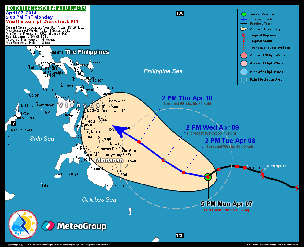
As of 5:00 PM PhT today...0900 GMT.
Location: Over the eastern part of South Philippine Sea (near 6.5N 131.9E)
About: 295 km west-southwest of Koror, Palau...or 610 east-southeast of Cateel, Davao Oriental
Maximum Sustained Winds (1-min avg): 45 kph near the center...Gustiness: 65 kph
24 hr. Rain Accumulation (near and west of the center): 2 to 450 mm [Slight to Extreme]
Size (in diameter): 610 km (Small)
Past Movement: Southwest at 15 kph
Forecast Movement: West to West-Northwest at 07 kph
Towards: Northeastern Mindanao
3-DAY FORECAST OUTLOOK*
Peipah (Domeng) is expected to move westward to west-northwest slowly within the next 24 to 48 hours and will turn northwestward through 72 hours. On the forecast track, the weak core of TD Peipah will continue to traverse the South Philippine Sea through Thursday...and shall approach the eastern coast of Surigao Provinces on Thursday afternoon.
Peipah (Domeng) is expected to maintain its strength within the next 12 hours...and re-intensify slightly within the next 48 hours. Advance Intensity Forecast (AIF) shows its 1-minute maximum sustained winds increasing back to 55 kph on Wednesday afternoon.
The following is the summary of the 3-day forecast outlook on this system:
TUESDAY AFTERNOON: Remains a weak Tropical Depression (TD) while turning WNW across the South Philippine Sea...about 430 km ESE of Cateel, Davao Oriental [2PM APR 08: 6.8N 130.3E @ 45kph]. WEDNESDAY AFTERNOON: Turns NW across the western part of South Philippine Sea...about 285 km E of Cateel, Davao Oriental [2PM APR 09: 7.6N 129.0E @ 55kph]. THURSDAY AFTERNOON: Maintains its strength as it approaches the east coast of Surigao Provinces...about 140 km NE of Bislig City, Surigao Del Sur [2PM APR 10: 8.8N 127.4E @ 55kph].
*Please be reminded that the Forecast Outlook changes every 6 hours, and the Day 2 and 3 Forecast Track has an average error of 100 and 250 km respectively...while the wind speed forecast error, averages 35 kph per day. Therefore, a turn to the left or right of its future track and changes in its wind speed must be anticipated from time to time.
Important Note: Please keep in mind that the above hazards summary and forecast outlook changes every 6 to 12 hrs!
ADDITIONAL DISTANCES & TECHNICAL INFO
Time/Date: 5:00 PM PhT Mon Apr 07, 2014
Class/Name: TD Peipah (Domeng)
Minimum Central Pressure: 1002 millibars (hPa)
Location of Center: Near 6.5º N Lat 131.9º E Lon
Distance 1: 295 km WSW of Koror, Palau
Distance 2: 610 km ESE of Cateel, Davao Oriental
Distance 3: 645 km SE of Bislig City
Distance 4: 750 km SE of Siargao Island
Distance 5: 795 km SE of Surigao City
T2K/WP StormTrack (for Public): GIF
CURRENT TRACKING MAP:
 _____________________________________________________________________________
__________________________________________________________________________________________________
CURRENT NOAA/MTSAT-2 INFRARED (IR) SATELLITE IMAGE:

__________________________________________________________________________________________________
>> To know the meteorological terminologies and acronyms used on this update visit the ff:
http://typhoon2000.ph/tcterm.htm
http://www.nhc.noaa.gov/aboutgloss.shtml
http://www.nhc.noaa.gov/acronyms.shtml
For the complete details on TD PEIPAH (DOMENG)...go visit our website @:
> http://www.typhoon2000.com
> http://www.maybagyo.com
Copyright © 2014 Typhoon2000.com All Rights Reserved
| Reply via web post | Reply to sender | Reply to group | Start a New Topic | Messages in this topic (1) |

No comments:
Post a Comment