
for Sunday, 06 April 2014 [7:52 PM PhT]
Issued at: 6:00 AM PhT (22:00 GMT) Sunday 06 April 2014
Next Update: 6:00 PM PhT (10:00 GMT) Sunday 06 April 2014
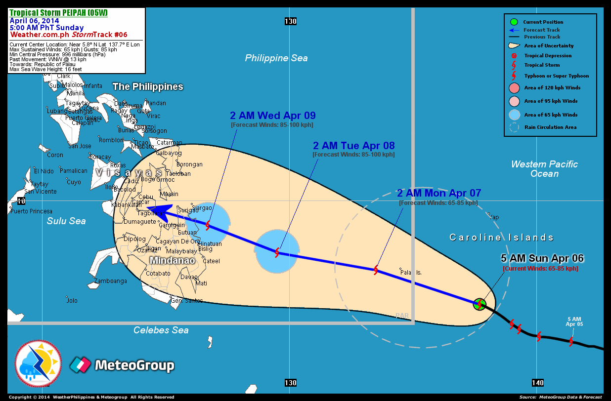
Tropical Storm PEIPAH has slowed down during past 12 hours as it maintains its track and strength...moving closer to the Republic of Palau as its heavy rainbands has started to spread across the area. This storm is expected to enter the Philippine Area of Responsibility (PAR) early tonight and pass very close to Palau. The potential landfall area of this storm remains along the Surigao Del Sur-Surigao Del Norte Area on Wednesday, April 9.
Residents and visitors along Western Micronesia including the Republic of Palau and the Philippines should closely monitor the development of TS Peipah.
Information based on data collected by WeatherPhilippines Foundation, Inc. shall not be taken as official data. Weather information broadcasted and distributed by PAGASA remains as official data. WeatherPhilippines shall not be responsible for the private use and reliance of its weather information.
CURRENT CYCLONE INFORMATION
As of 5:00 AM PhT today...2100 GMT...
Location: Over the Southernmost Caroline Islands (near 5.8N 137.7E)
About: 385 km southeast of Koror, Palau...or 1,265 km east-southeast of Southern Mindanao, Philippines
Maximum Sustained Winds (1-min avg): 65 kph near the center...Gustiness: 85 kph
24 hr. Rain Accumulation (near and west of the center): 2 to 300 mm [Slight to Extreme]
Size (in diameter): 665 km (Small)
Past Movement: West-Northwest at 13 kph
Forecast Movement: West-Northwest at 22 kph
Towards: Republic of Palau
3-DAY FORECAST OUTLOOK*
Peipah is expected to continue moving generally west-northwestward with a gradual decrease in its forward speed throughout the forecast period. On the forecast track, the core of TS Peipah will passing over or very close to Palau by Sunday evening as it enters the PAR. It will then be over the central part of the South Philippine Sea by early Tuesday morning. By early Wednesday morning, the storm shall be just along the eastern coast of the northern part of Surigao Del Sur...prepares to make landfall.
Peipah is expected to slowly gain strength within the next 24 to 48 hours...and shall maintain its strength through 72 hours. Advance Intensity Forecast (AIF) shows its 1-minute maximum sustained winds increasing to 85 kph by early Tuesday morning.
The following is the summary of the 3-day forecast outlook on this system:
 MONDAY EARLY MORNING: Maintains its strength while moving WNW across the South Philippine Sea, away from the Republic of Palau...about 110 km W of Koror, Palau [2AM APR 07: 7.2N 133.5E @ 65kph]. TUESDAY EARLY MORNING: Strengthens further as it continues to move across the South Philippine Sea, closer to Surigao Provinces...about 355 km ESE of Bislig City [2AM APR 08: 7.9N 129.5E @ 85kph]. WEDNESDAY EARLY MORNING: Just along the eastern coast of the northern part of Surigao Del Sur...maintains its strength...about 120 km SSE of Siargao Island [2AM APR 09: 9.0N 126.7E @ 85kph].
CYCLONE HAZARDS AFFECTING LAND
Below are the regions or places in the Philippines with possible or ongoing effects caused by the current tropical cyclone.
EASTERN AND NORTHEASTERN MINDANAO: Heavy rains of 50 to 100 mm are likely to be experienced beginning Tuesday morning until Friday morning...becoming heavy to extreme rains of more than 100 mm with Tropical Storm Force Winds of not more than 85 kph across the provinces of Surigao Del Norte, Surigao Del Sur and Dinagat including Siargao Island. Residents in these areas are advised to be always on alert and closely monitor the weather situation for possible changes in its forecast.
Important Note: Please keep in mind that the above forecast outlook and hazards summary changes every 6 to 12 hrs!
ADDITIONAL DISTANCES & TECHNICAL INFO
Time/Date: 5:00 AM PhT Sun Apr 06, 2014
Class/Name: TS Peipah (05W)
Minimum Central Pressure: 996 millibars (hPa)
Location of Center: Near 5.8º N Lat 137.7º E Lon
Distance 1: 300 km E of P.A.R.
Distance 2: 385 km SE of Koror, Palau
Distance 3: 415 km S of Yap Is.
Distance 4: 1150 km SW of Hagatna, Guam
Distance 5: 1265 km ESE of Southern Mindanao, PHL
T2K/WP StormTracks (for Public): GIF
CURRENT TRACKING MAP:
 _____________________________________________________________________________
__________________________________________________________________________________________________
CURRENT NOAA/MTSAT-2 INFRARED (IR) SATELLITE IMAGE:

__________________________________________________________________________________________________
>> To know the meteorological terminologies and acronyms used on this update visit the ff:
http://typhoon2000.ph/tcterm.htm
http://www.nhc.noaa.gov/aboutgloss.shtml
http://www.nhc.noaa.gov/acronyms.shtml
For the complete details on TS PEIPAH (05W)...go visit our website @:
> http://www.typhoon2000.com
> http://www.maybagyo.com
Copyright © 2014 Typhoon2000.com All Rights Reserved
| Reply via web post | Reply to sender | Reply to group | Start a New Topic | Messages in this topic (1) |

No comments:
Post a Comment